Chapter 1 Standards and class objectives.
Standards
G.1.AH.7-8.1-5
Objectives
G.1.AH.7-8.1-5
Objectives
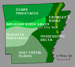
- Compare and contrast the six geographical land regions of Arkansas.
- Identify and map the major rivers of Arkansas.
- Describe factors contributing to the settlement of Arkansas (climate, waterways, accessibility)
- Research the origins of key places names in Arkansas.
- Examine the economic effect of Arkansas' natural resources: diamonds, bauxite, forestry products, and oil.

1/7/13
Starter: Define Key terms in quizlet from chapter 1 on page 3.
Class work: Read pages 4-15. Group book walk.
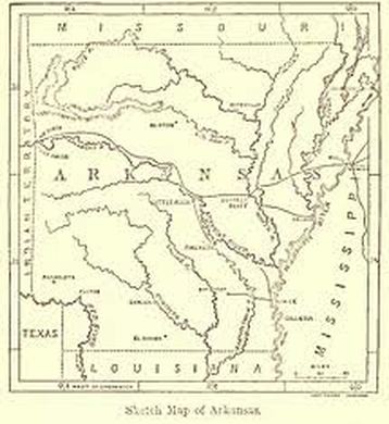
Early Arkanas map
|
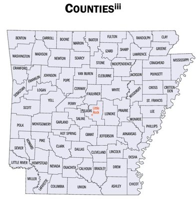
Current Arkansas County Map
|
1-8 Starter: Timeline Activity & Race - 10 minutes for directions and activity!
without talking follow the directions below. You have 5 minutes to complete these tasks.
1. Take out a sheet of paper and a pencil.
2. Cut your sheet of paper into 4 pieces
3. With your table/group look at the timeline on pages 2 & 3.
4. Each person must write the information for each section onto their 4 pieces of paper. ALL INFORMATION MUST BE INCLUDED!
When I give the signal the practice race will begin. Your goal is to put the information in order as fast as you can!
Each group will compete against the clock to find their best time.
After you have practiced the groups will compete against each other without using the book.
Classwork:
Read pages 4-15 aloud/ popcorn style!
G.1.AH.7-8.1
1-9 Starter: Read the flip book below and complete any missing terms in quizlet.
Be sure you read the whole flipbook!
Class work: Notes and Questions about "The Land We Call Arkansas"
G.1.AH.7-8.5
1/10 Starter -
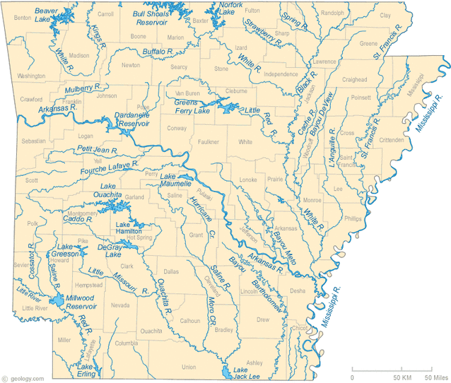
Look at the map on page 305. Make a list of all the rivers and label it "rivers" then
make a list of all the lakes and reservoirs and label it "lakes and reservoirs".
notes pages 11-15
G.1.AH.7-8.1
G.1.AH.7-8.1
1/10 Class work
Create a map of Arkansas just like the one on page 305.
Be sure to label all of the lakes, reservoirs, and rivers on your map.
We will cut your map out so keep within the outline of the state.
G.1.AH.7-8.1
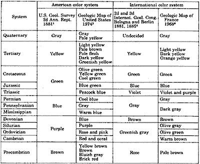
1/13 Starter: Look at the map below on your computer.
Find the blue areas, BLUE does NOT mean water on this map. List all the colors shown on the map.
You will use this list in our class work you have 5 minutes to list all 15. You can describe them as lightest, light, medium, dark and darkest for each color, but you must make a complete list in a table. You have 5 minutes!
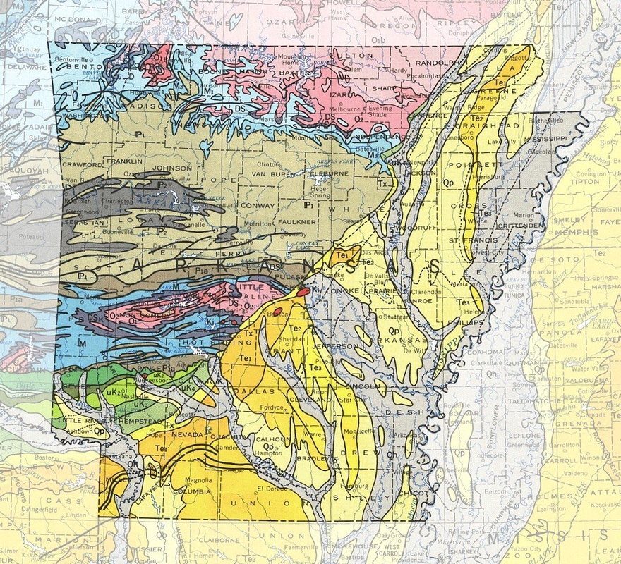
Geological Map of Arkansas
G.1.AH.7-8.5
G.1.AH.7-8.5
1/11 Classwork: Notes and Activity below.
Research "Arkansas Geology Maps"
Make a key for the colors.
Find out what each color represents and label your key correctly.
Use the book below to find a chart or key for the color standards of geolocical maps, you may also try the internet.
1/14 Starter
Review your quizlet terms for the quiz!!
Ch 1 pages 4-15 quiz in moodle.
Standards
G.1.AH.7-8.1-5
Your Map From page 302 and Family Tree is due today!
After the quiz Read pages 16-31
1-15
|
Class work:
|
1/16 Starter
Finish your Flipagram/family.tree.map
Then...work on the Arkansas Land Regions Chart - complete the chart then I will divide you into groups.
Classwork: Arkansas Land Regions project
Each group will describe and illustrate one of the six land regions. Each group will use pictures or draw items from the region onto a class poster of Arkansas.
The class with the best poster will win a popcorn party.
Standards
G.1.AH.7-8.1-5
Pages 16-31 this project will be due 1/23!
1/17 Starter:.Review for the chapter 1 quiz.
(quizlet terms, fill in the blank notes and your land region chart)
Classwork:
Log into Moodle and enroll in Arkansas History, the passkey is quapaw!
Then find the Chapter 1 quiz in Moodle!
1/20 Starter: Click the link to answer the starter,
Potts Inn in the Arkansas River Valley.
Classwork: work with your group to complete the Land Region Project.
Be sure to include crops, trees, land or water forms, companies, or any other iconic part of the region.
Standards
G.1.AH.7-8.1-5
Please complete the survey about your computer use:
https://docs.google.com/a/pottsvilleschools.org/spreadsheet/viewform?fromEmail=true&formkey=dElkNEFOR0gwb29VQ3pHdC1VTkJyeVE6MQ
Standards
G.1.AH.7-8.1-5
Please complete the survey about your computer use:
https://docs.google.com/a/pottsvilleschools.org/spreadsheet/viewform?fromEmail=true&formkey=dElkNEFOR0gwb29VQ3pHdC1VTkJyeVE6MQ
1/21 Starter : Look at the map on page 305. Make a list of all the rivers and label it "rivers" then make a list of all the lakes and reservoirs and label it "lakes and reservoirs" draw, color and label the lakes and rivers. Put your name on the back!
After you finish the starter review your quizlet terms and study for the Ch 1 test in Moodle!
When everyone is finished you may work on your Land Region Project.
Standards
G.1.AH.7-8.1-5
When everyone is finished you may work on your Land Region Project.
Standards
G.1.AH.7-8.1-5
1/22 Starter : Click the link to Question of the Day!and classwork: Finish your Land Region Project!!!
Due Tomorrow!
